
As my departure date for Nepal drew near, I found that most people assumed I was trekking to Everest Base Camp (EBC). I knew I wasn’t, but the fact was, prior to arriving in Nepal and taking a good look at a map of the Everest Region (also known as the Khumbu), I really didn’t know what my destination was. As I read our tentative itinerary, it seemed we were hiking up one way, then back down a bit, then up another way and then all the way back down. I didn’t realize that we were actually following a popular alternative to the EBC trek. We were heading to Gokyo Ri, a peak at an elevation just about the same as EBC and one offering a view straight across at Mount Everest.
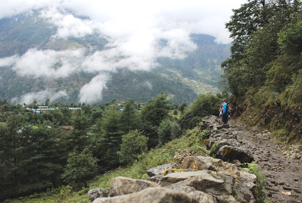
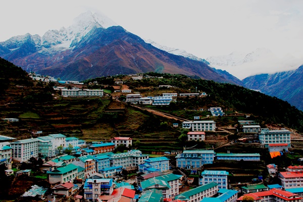
Almost all treks in the Khumbu begin the same – by flying into Lukla, at an altitude of 2840 meters. While some ambitious groups make the trek from Lukla to Namche Bazaar, the largest village in the region, in one day, we broke that journey up into two days. We arrived in Lukla by about 9:30 a.m. and stopped at a lodge near the airport for tea as our dzokyos (a cross between a cow and a yak) were loaded up with our bags. From Lukla, it was mostly downhill to the village of Phakding, which sits lower at 2610 meters. The next day, we headed mostly uphill from Phakding to Namche, arriving in the pouring rain. With Namche sitting at 3440 meters, we ascended nearly 800 meters in what we were told would be one of the toughest days of the two week trek.
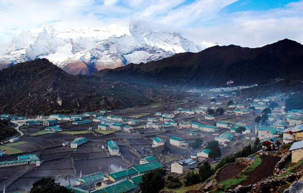
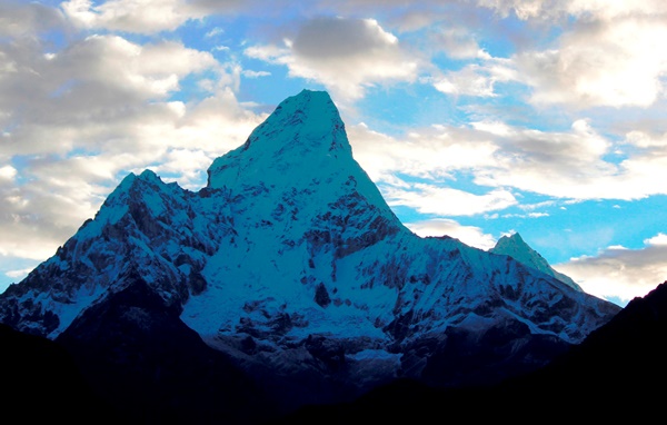
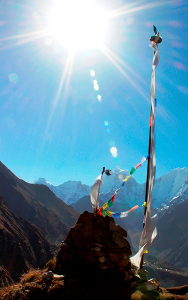
After a full day in Namche to acclimatize (fairly standard for almost all trekking groups), we split off from the majority of trekkers who were heading to EBC. We followed the Dudh Khosi (a river) up to Gokyo while the EBC trekkers followed one of its tributaries, the Imja Khola. Our next stop would be the village of Khumjung, the hometown of our Sherpa guide, Kami, at an altitude of 3780 meters. We reached Khumjung by lunch and spent a much-needed afternoon relaxing and eating popcorn as rain poured down outside. The next morning, with clear skies, we were able to enjoy our first views of another popular peak in the Khumbu – Ama Dablam. Before heading out for the day, we stopped at the Khumjung Monastery, where we got to take a peek at what is allegedly a Yeti scalp, and at the first Hillary School, found by Sir Edmund Hillary.
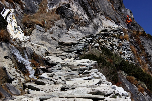
The trek from Khumjung to our next stop, Mong La (3957 meters), was short, not too hard and unfortunately a bit foggy. From Mong La, we headed on to Dole enjoying our first full day of sunshine! The trek itself started with about an hour of downhill and then about two and a half hours of straight uphill, with several sections of what I liked to call “the stairs of death.” Luckily, there were also plenty of opportunities to stop and take pictures of our gorgeous surroundings. After lunch in Dole (4110 meters), we headed up a bit further to acclimatize some more and encountered an amazing field of flowers that was hell for my allergies but heaven for taking photos.


From Dole, it was on to Machermo – another day of sunshine and another relatively easy day. We arrived by lunch and in the afternoon, went to the Porter Rescue Station to hear a talk on altitude sickness. Sitting at 4470 meters, Machermo was officially the highest altitude I had ever reached, beating out the Dead Woman’s Pass on the Inca Trail.
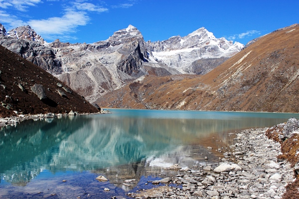
The next day was a tough one, going from Machermo to Gokyo (4790 meters), which would be our base for climbing up to Gokyo Ri the next morning. Because there were no real villages along the way, we packed bag lunches, which we ate along the shores of the first of the Gokyo Lakes (known simply as the First Lake). This was a challenging day with more stairs from hell, but also incredibly scenic. After the First Lake, we passed the Second Lake before arriving in Gokyo, which sits next to the Third Lake. It could not have been a more perfect setting: the sun was shining, the lake was sparkling, the temperature actually felt warm.
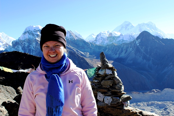
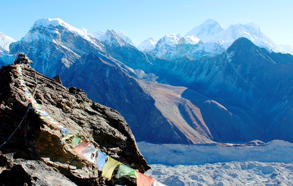
Finally, the next morning we reached our version of EBC – the peak of Gokyo Ri, at an altitude of 5357 meters (EBC is at 5364 meters). We departed at 3:30 a.m. and, after a stop about two-thirds of the way up to take pictures as the sun rose, we reached the top by about 7:00 a.m. I’ll write more about that in another post, but suffice it to say I could have stayed up there all day enjoying the view.
The next day, we started heading back down, retracing our steps to Dole in one day and then crossing the Dudh Khosi to arrive in Pengboche (3930 meters) the next day. The trek from Dole to Pengboche, with a stop in Phortse for lunch, was one of the most strenuous, with long stretches of downhill followed by longer stretches of uphill, often with steep, stony steps. The incredible views made up for the difficulty and we were rewarded in Pengboche with a luxurious gas-heated, indoor shower that was heaven after the previous showers in Mong La and Gokyo.
From Pengboche, we had an easy half day trek to Tengboche (3860 meters), which sits at the confluence of the Dudh Khosi and the Imja Khola. Here, the trail suddenly got incredibly crowded. For a good part of the way up to Gokyo, we were often the only ones on the trail; we rarely passed others heading down and only encountered a handful of other groups going up. That all changed between Pengboche and Tengboche as we were on the same path as the trekkers going up to EBC. Where the trail was narrow, we often had to wait for several minutes for groups to go by before we could continue on our way down.
Tengboche should have been quite scenic, but instead it was just rainy and muddy. The same can be said for the trek from Tengboche back to Namche Bazaar the next day. While I had been looking forward to returning to Namche to explore the bustling village and take a lot of pictures since it was raining the first time we passed through, it was raining even more when we returned.
Altogether, our trek to Gokyo Ri took a couple days longer than most treks to and from EBC do, but we also went quite slow – a few of the groups that we did run into on the way up were going a bit faster than we were. I liked the fact that it was likely much less crowded than the EBC trail and that often, we had our teahouse all to ourselves – meaning we could claim extra blankets at night, didn’t have to wait long for the sole shower and could take over the whole dining room.
Interestingly, as we talked to people in Kathmandu, Namche and Lukla, almost no one had heard of Gokyo Ri. The one guy who had commented, “wow, that’s supposed to be really tough. Good job!”
While I think he was thinking of another peak, I didn’t bother to correct him.
Great, informative post! Which month did you do this in? And is the Gokyo Ri trek different from the Gokyo Lakes trek, or just another name for the same thing?
I think it’s probably similar, but I’m guessing you may go a bit further with the Gokyo Lakes trek – I don’t think we went by all the Gokyo lakes.
Hi Katie, absolutely thrilling to read your narrative on the Gokyo-Ri, exceptionally well written and gave me a sense as if I was visualising things as I read. Just for information sake I am a landscape photographer and is interested to photograph in this region, as I read above in your comment that a two week period would be suitable for this trek will it be enough or need to keep extra days in hand secondly can you please share the itinerary and the travel agents/guides that facilitate this trek…would appreciate greatly. Once again thank you very much for an excellent write up. Best wishes.
Hi Katie, came across your blog while googling Gokyo-Ri. All being well, myself my husband and another leader will be taking a group of Explorer Scouts to Nepal this December. We’ll be flying to Lukla and taking part in a guided trek to Gokyo-Ri, so it has been great to read your description and see the photos. Looking forward to it even more now! Has reminded me to buy some good knee supports though! Thanks for sharing your experience. We fly out to Kathmandhu December 13 and will be starting from Lukla a couple of days later. Any ideas what the weather will be like? It looks like you were there November, with quite a lot of rain? Thanks, Philippa
Hi there. Did you hire a guide and a porter, or just a guide/porter? Was your guide OK about the slower than normal schedule?
Hi Katie, My 17 year old daughter Maddison is at Gokyo Ri camp as I write this note! As there is no contact or photo’s from her to see, I have followed her trek plan daily & looked at pics from the net to sort of do the journey with her! She is travelling with her outdoor leadership group from school with everything planned through World Expeditions, have been very impressed with all contact & info received through them leading up to the trip. I hope & am sure this journey will be life changing for her & open her eyes to a totally different way of life for people in other countries. The specky scenery & beautiful people of Nepal will I’m sure make her want to turn around & go straight back. She is due to arrive back in Australia next Friday 18th December after having the best 20 days of her life ( I hope). I guess she will be exhausted but exhilarated all at the same time, so looking forward to hearing her stories, seeing her photo’s & reading her journal!! I miss her heaps & can’t wait to kiss & hug her tight. I think this experience will be hard to beat!!
Thank you for sharing your info & photo’ s with us Katie.
Kind regards
Hi Katie, thinking of heading on this trip in Oct this year. Can I know which trekking company did you go with/hire the guide from?
Hi Tan – I didn’t go with a trekking company. The trip was a photography trek organized by a travel photographer in the US. He arranged for the guide, who he had worked with on previous trips. If you email me, I can send you the guide’s contact info.
Hi Katie,
Thanks for posting this lovely blog. It really helps give a sense of what this hike is all about. I’m heading to Nepal mid April and I’m looking to potentially complete this hike. I’m going to be hiking as a solo female, but I do have a decent background of hiking as well as a background in wilderness first aid. I’m wondering if you think this hike is possible to complete in a 14 day trip to Nepal. 2 of those days would include flights in and out of Kathmandu. What’s your take on it?
Cheers,
Kathleen
Thanks Kathleen!
I think it would be hard to hike all the way to Gokyo Ri with just 14 days in Nepal total. Flights between Kathmandu and Lukla (starting point for any hikes) are very dependent on weather conditions and you can get delayed by 1-3 days on either end of your trip if the weather is bad. We were delayed one day heading to Lukla and we met people who had been delayed 2 and 3 days.
Once you’re in Lukla, you need at least a day to get to Namche Bazaar (we went slower and took 2 days) and then you really should spend a full day in Namche to acclimatize. From there, up to Gokyo Ri is 5 days at its quickest (we took 6 days, any faster than 5 and I think you’re risking altitude sickness – we ran into people who had to come down because they tried to rush it too much). I think you could probably get all the way back down in 3-4 days if you really push it, but your knees may hate you. 🙂
Anyway, hopefully you see my point – you would be extremely rushed and you would have to luck out with flights between Lukla and Kathmandu running on schedule. I think there is still some nice hiking you could do in the region – even base yourself in Namche and do some day hikes from there. But going all the way up to Gokyo Ri would be tough. I also think Kathmandu is worth spending a little time exploring if you haven’t been before.
Happy to answer any other questions!
Thanks Katie. I’ve been researching and research, but I really just needed some first hand knowledge. I was also looking at Annapurna Base Camp. I should have booked for three weeks. I’m kicking myself for limiting it to two. I’ll just have to get back there.
Cheers,
Kathleen
Hi Katie! I have exactly 8 days to travel, and I was thinking of this trek! do you think it is possible to start from kathmandu, go for the trek, get back to kathmandu and fly out, all in 8 days? 🙂 Thank you for the reply!!
Hi Mou – unfortunately, that is not enough time. Flights to Lukla are very unpredictable so you could lose a day or two on either end due to flight delays. Even if you don’t, best case scenario, you would arrive in Kathmandu day 1, fly to Lukla day 2 and hike very best case as far as Namche. Day 3 you need to stay in Namche to acclimatize. Then you would have days 4, 5 and 6 to hike and get back to Namche before day 7 hiking back to Lukla and day 8 flying out of Lukla and out of Kathmandu. That’s not enough time to get to Gokyo Ri. That would also be absolutely best case scenario and would leave you absolutely no room for error and I would not recommend it. I would save it for a time when you have at least two weeks or more.
hey Katie! Thanks so much for your advice! I have decided to go in December instead, when I have more time. Thanks so much once again 🙂
Pingback: A lazy person at Plitvice Lakes - Olympic Wanderings
Great photos!
This brought back memories of when we did the Annapurna Circuit in Nepal – luckily for us, there weren’t any stairs on that trek!
Cheers.
Wish I had known that before – I may have done a different trek! 🙂
I’m so impressed with you for going on this trip. I’m such a wimp and so out of shape, there’s no way I could handle it. Gorgeous photos!
Thanks! It was definitely a challenge, but so worth it!
I became familiar with the area after slowly going through Richard L’Anson’s Lonely Planet photo-book called “Nepal”. Those photos and your photos are like an open call from afar. Thanks for writing about this, Katie.
I find this stuff so interesting because I could never in a million years fathom doing it. I’m very sensitive to altitude and even visiting Breckinridge in Colorado was miserable for me. Did you do anything to prevent altitude sickness?
Yep, I took Diamox, which I think helped, although I found out halfway through that I was only taking half the recommended dose. 🙂 We also went really slow – much slower than other trekking groups.
Stunning pictures Katie. The Third Lake especially. Making me have second thoughts on our decision to not return to Nepal in 2014…hmmm…maybe 2015!
Thanks Gillian! There’s a 4th and 5th lake too, but we were too exhausted to trek to those. I’m sure they were amazing as well! Keep those in mind if you go back!